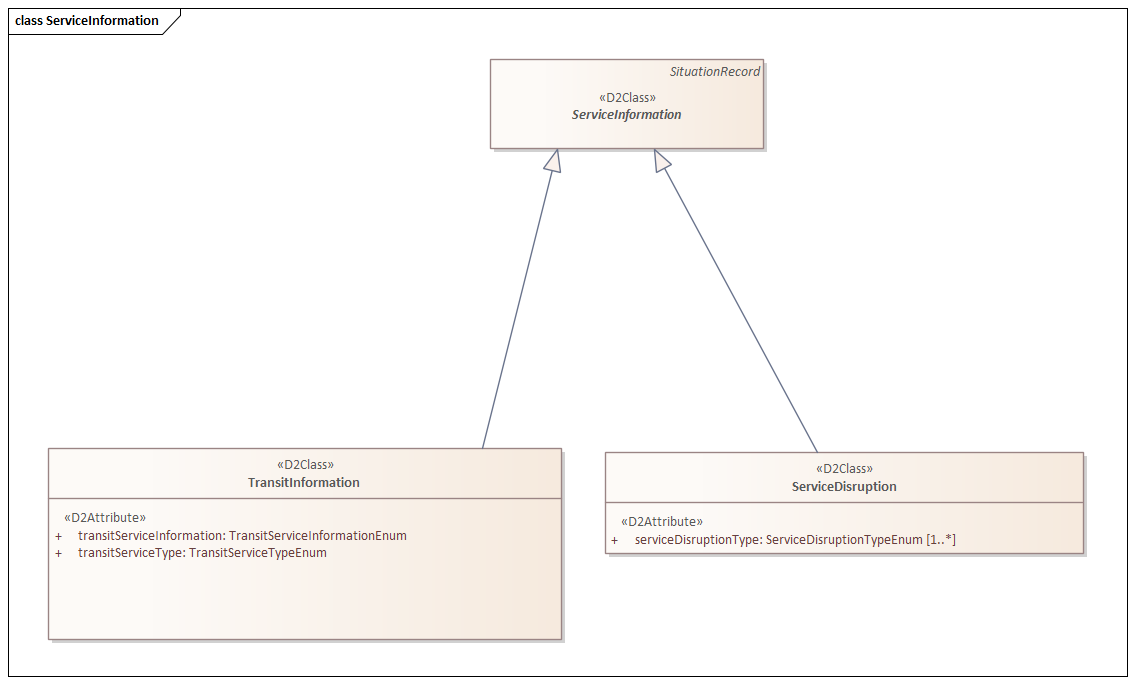
TransitInformation
Specialization TransitInformation (Availability of Public Transport and Departure Time Information)
The TransitInformation
specialization falls under the ServiceInformation
umbrella. The TransitInformation
specialization describes the availability of (public) transport services (as far as relevant for road users) and information related to departure times. In addition to the elements from NonRoadEventInformation
the specialization includes the mandatory elements transitServiceInformation
and transitServiceType
:
Elements
An overview of elements present in each specialization of a situationRecord
can be found hereIn the case of the TransitInformation
specialization, these elements are supplemented with additional elements:
Element | Type | Mandatory | Domain | Description |
---|---|---|---|---|
transitServiceInformation | TransitServiceInformationEnum | Yes | cancellations, delayDueToBadWeather, delayDueToRepairs, delayedUntilFurtherNotice, delaysDueToFlotsam, departureOnSchedule, ferryReplacedByIceRoad, freeShuttleServiceOperating, informationServiceNotAvailable, irregularServiceDelays, loadCapacityChanged, restrictionsForLongerVehicles, serviceDelays, serviceDelaysOfUncertainDuration, serviceFullyBooked, serviceNotOperating, serviceNotOperatingSubstituteServiceAvailable, serviceSuspended, serviceWithdrawn, shuttleServiceOperating, temporaryChangesToTimetables, other | Information regarding (public) transport services. |
transitServiceType | AuthorityOperationTypeEnum | Yes | air, bus, ferry, hydrofoil, rail, tram, undergroundMetro | Type of the concerned (public) transport service(s). |
<?xml version="1.0" encoding="UTF-8" standalone="yes"?>
<mc:messageContainer modelBaseVersion="3" xmlns:inf="http://datex2.eu/schema/3/informationManagement" xmlns:com="http://datex2.eu/schema/3/common" xmlns:loc="http://datex2.eu/schema/3/locationReferencing" xmlns:ex="http://datex2.eu/schema/3/exchangeInformation" xmlns:mc="http://datex2.eu/schema/3/messageContainer" xmlns:nle="http://datex2.eu/schema/3/nlExtensions" xmlns:nlxe="http://datex2.eu/schema/3/nlxExtensions" xmlns:srx="http://datex2.eu/schema/3/situationRecordExtension" xmlns:sit="http://datex2.eu/schema/3/situation">
<mc:payload xsi:type="sit:SituationPublication" lang="nl" modelBaseVersion="3" xmlns:xsi="http://www.w3.org/2001/XMLSchema-instance">
<com:publicationTime>2024-09-27T06:12:09.940Z</com:publicationTime>
<com:publicationCreator>
<com:country>nl</com:country>
<com:nationalIdentifier>NLNDW</com:nationalIdentifier>
</com:publicationCreator>
<sit:situation id="RWS01_SM947665_D2">
<sit:overallSeverity>medium</sit:overallSeverity>
<sit:situationVersionTime>2024-09-27T06:12:09.940Z</sit:situationVersionTime>
<sit:headerInformation>
<confidentiality>noRestriction</confidentiality>
<informationStatus>real</informationStatus>
</sit:headerInformation>
<sit:situationRecord xsi:type="sit:TransitInformation" id="RWS01_SM947665_D2_REC" version="1">
<sit:situationRecordCreationTime>2024-09-27T06:12:09.940Z</sit:situationRecordCreationTime>
<sit:situationRecordVersionTime>2024-09-27T06:12:09.940Z</sit:situationRecordVersionTime>
<sit:probabilityOfOccurrence>certain</sit:probabilityOfOccurrence>
<sit:source>
<com:sourceName>
<com:values>
<com:value lang="nl">NLNDW</com:value>
</com:values>
</com:sourceName>
</sit:source>
<sit:validity>
<com:validityStatus>definedByValidityTimeSpec</com:validityStatus>
<com:validityTimeSpecification>
<com:overallStartTime>2024-09-27T05:12:09.940Z</com:overallStartTime>
<com:overallEndTime>2024-10-27T08:12:09.940Z</com:overallEndTime>
</com:validityTimeSpecification>
</sit:validity>
<sit:locationReference xsi:type="loc:PointLocation">
<loc:supplementaryPositionalDescription>
<loc:carriageway>
<loc:carriageway>mainCarriageway</loc:carriageway>
</loc:carriageway>
</loc:supplementaryPositionalDescription>
<loc:pointByCoordinates>
<loc:bearing>125</loc:bearing>
<loc:pointCoordinates>
<loc:latitude>52.18495</loc:latitude>
<loc:longitude>5.4378614</loc:longitude>
</loc:pointCoordinates>
</loc:pointByCoordinates>
<loc:alertCPoint xsi:type="loc:AlertCMethod4Point">
<loc:alertCLocationCountryCode>8</loc:alertCLocationCountryCode>
<loc:alertCLocationTableNumber>6.10</loc:alertCLocationTableNumber>
<loc:alertCLocationTableVersion>A</loc:alertCLocationTableVersion>
<loc:alertCDirection>
<loc:alertCDirectionCoded>positive</loc:alertCDirectionCoded>
<loc:alertCAffectedDirection>aligned</loc:alertCAffectedDirection>
</loc:alertCDirection>
<loc:alertCMethod4PrimaryPointLocation>
<loc:alertCLocation>
<loc:specificLocation>8479</loc:specificLocation>
</loc:alertCLocation>
<loc:offsetDistance>
<loc:offsetDistance>0</loc:offsetDistance>
</loc:offsetDistance>
</loc:alertCMethod4PrimaryPointLocation>
</loc:alertCPoint>
</sit:locationReference>
<sit:transitServiceInformation>serviceSuspended</sit:transitServiceInformation>
<sit:transitServiceType>ferry</sit:transitServiceType>
</sit:situationRecord>
</sit:situation>
</mc:payload>
<mc:exchangeInformation modelBaseVersion="3">
<ex:exchangeContext>
<ex:codedExchangeProtocol>snapshotPull</ex:codedExchangeProtocol>
<ex:exchangeSpecificationVersion>3</ex:exchangeSpecificationVersion>
<ex:supplierOrCisRequester>
<ex:internationalIdentifier>
<com:country>nl</com:country>
<com:nationalIdentifier>NLNDW</com:nationalIdentifier>
</ex:internationalIdentifier>
</ex:supplierOrCisRequester>
</ex:exchangeContext>
</mc:exchangeInformation>
</mc:messageContainer>
*[AFIR]: Alternative Fuels Infrastructure Regulation
*[AI]: Artificial Intelligence
*[ALERT-C]: Adevice and Problem Location for European Road Traffic, Version C
*[ANPR]: Automatic Number Plate Recognition
*[APDS]: Alliance for Parking Data Standards
*[API]: Application Programming Interface
*[ARAMIS]: Advanced Ringroad And Mobility Information System
*[AVB]: Architectuur voor VerkeersBeheersing
*[AVC 2002]: Algemene Vervoercondities 2002
*[AVD]: Average Vehicle Distribution
*[AVG]: Actuele VerkeersGegevens
*[BAT]: Bereikbaarheid Analyse Tool
*[BDF]: BiDirectional Flow
*[BGT]: Basisregistratie Grootschalige Topografie
*[BGV]: Blauwe Golf Verbindend
*[BIB]: Bron Indicatoren Bestand
*[BO MIRT]: Bestuurlijk Overleg Meerjarig Infrastructuur Ruimte en Transport
*[BPS]: Beschrijvende Plaatsaanduiding Systematiek
*[BRON]: Bestand geRegistreerde Ongevallen Nederland
*[BRT]: BasisRegistratie Topografie
*[BRV]: BasisRegistratie Voertuigen
*[BVG]: Basisbestand VerkeersGegevens
*[CALYPSO]: Contactless eTicketing Application
*[CAM]: Cooperative Awareness Message
*[CBM]: Configuratie Beheer Manager
*[CBS]: Centraal Bureau voor de Statistiek
*[CCAM]: Cooperative, Connected, and Automated Mobility
*[CDMS]: Centraal DRIP Management Systeem
*[CHB]: Centraal Halte Bestand
*[C-ITS]: Cooperative Intelligent Transport Systems
*[CMI]: Centraal Meldpunt Incidenten
*[CMR]: Convention relative au contrat de transport international de marchandises par route
*[CMV]: Centraal Meldpunt Vrachtautoincidenten
*[CNS]: Centraal NDW Systeem
*[CoRoM]: Coordination and standardisation of booking and payment interfaces for rail mobility
*[CPO]: Charge Point Operator
*[CTC]: Connected Transport Corridors
*[CurbLR]: Curb Linear Reference
*[CV]: Connected Vehicles
*[CVMS]: Centraal VRI Management Systeem
*[CWVL]: Coordinerende wegverkeersleider
*[D4T]: Data 4Traffic
*[Dafne]: Dutch Alternative Fuels National Endpoint
*[DAP]: Dossier, Afspraken en Procedures
*[Data4PT]: Data-Driven Decision Making for Public Transport
*[DATEX]: DATa Exchange
*[DATEX II ]: DATa EXchange versie 2
*[DaVinci]: Data Validatie en INspectie voor de Corporate Informatieketen
*[DCV]: Data Communication on Vehicles
*[DENM]: Decentralized Environmental Notification Message
*[DEXTER]: Data EXploration en exporTER tool
*[DIL]: Digitale Infrastructuur Logistiek
*[DITCM]: Dutch Integrated Test Site Cooperative Mobility
*[DIVV]: Dynamisch inhaalverbod vrachtverkeer
*[DMI]: Dutch Metropolitan Innovations
*[DO]: Directeuren Overleg
*[DOT]: DoorOntwikkel Tafel
*[DOT-NL]: Dataplatform Openbare Toegankelijke laadpunten Nederland
*[DOVA]: Decentrale OV-Autoriteiten
*[DRIP]: Dynamisch Route-Informatie Paneel
*[DSM]: Digitaal Stelsel Mobiliteitsdata
*[DSO]: Distribution System Operator
*[DT15]: DataTop 15
*[DTM]: Digitale Transitie Mobiliteit
*[DVD]: Detailed Vehicle Data
*[DVM]: Dynamisch VerkeersManagement
*[DVM(X)]: DVM Exchange
*[DVS]: Dienst Verkeer en Scheepvaart
*[Dynamax]: Dynamische Maximum Snelheid
*[eBL]: elektronische Bill of Lading
*[eCMR]: Elektronische CMR (Convention relative au contrat de transport international de marchandises par route)
*[EDI]: Electronic Data Interchange
*[EDIB]: European Data Innovation Board
*[EDIC]: European Digital Infrastructure Consortium
*[EDP]: Externe Data Provider
*[EETS]: European Electronic Toll Service
*[eFTI]: Electronic Freight Transport Information
*[eIDAS]: Electronic Identification and Trust Services
*[EMDS]: European Mobility Data Space
*[ERTMS]: European Rail Traffic Management System
*[ESB]: Enterprise Service Bus
*[EV]: Elektrisch Voertuig
*[FB]: Functioneel Beheer
*[FCD]: Floating Car Data
*[FD]: Flow Development
*[FOT]: Field Operational Test
*[GBFS]: General Bikeshare Feed Specification
*[GDF]: Geographic Data File
*[GDPR]: General Data Protection Regulation
*[George]: GEOgrafische Registratie van Gegevens
*[GGB]: GebiedsGericht Benutten
*[GLOSA]: Green Light Optimal Speed Advisory
*[GNMI]: Gemeentelijk Netwerk voor Mobiliteit en Infrastructuur
*[GOFS]: General On-demand Feed Specifcation
*[GRIP]: Grafisch Route Informatie Paneel
*[GROUN]: Gegevensuitwisseling ROUteplanners en Navigatiesystemen
*[GTFS]: General Transit Feed Specification
*[GTFS-Flex]: General Transit Feed Specification - Flexible Services
*[GTFS-Ride]: General Transit Feed Specification Ride
*[HB]: Herkomst & Bestemmingsdata
*[HBR]: HavenBedrijf Rotterdam
*[HWN]: HoofdWegen Net
*[I/C-verhouding]: Intensiteit / Capaciteit verhouding
*[IDEA]: Intelligent Data Exchange Alliance
*[IDP]: Interne Data Provider
*[IDTM]: Impact Driven Traffic Management
*[IFOPT]: Identification of Fixed Objects in Public Transport
*[IHW]: InformatieHuis Wegverkeersgegevens
*[ILT]: Inspectie Leefomgeving en Transport
*[IMA]: Integrale MobiliteitsAnalyse
*[IMBOR]: InformatieModel Beheer Openbare Ruimte
*[IMGeo]: Informatiemodel Geo-Objecten
*[IMO]: Interactieve MOnitor
*[IMSpoor]: Informatiemodel Spoor
*[IMWV]: InformatieModel Wegen en Verkeer
*[INSPIRE]: Infrastructure for Spatial Information in Europe
*[INWEVA]: INtensiteiten op WEgVAkken
*[IRS]: Interface Requirements Specifications
*[ISA]: Intelligent Speed Assistance
*[ITS]: Intelligent Transport Systems
*[IVIM]: Infrastructure to Vehicle Information Message
*[IVP]: Individuele VoertuigPassage
*[iVRI]: Intelligente VerkeersRegelInstallatie
*[IXSI 5]: Interface for XML-based Systems Integration version 5
*[KARIN]: Krachtige Administratietool Referentielocaties In Nederland
*[KiM]: Kennis instituut voor Mobiliteitsbeleid
*[KPI]: Key Performance Indicator
*[LDKO]: Landelijk Data Keten Overleg
*[LINDA]: LaadINfra DAtaplatform
*[LVMB]: Landelijk VerkeersManagement Beraad
*[LZV]: Langere en Zwaardere Vrachtautocombinatie
*[MaaS]: Mobility as a Service
*[MAP]: Map message
*[MAPEM]: Map Extended Message
*[MCP]: Multi-Country Project
*[MDMS]: Multimodal Digital Mobility Services
*[MDP]: Measurement Data Publication
*[MDS]: Mobility Data Specification
*[MDV]: MaaS DienstVerlener
*[Melvin]: MELden van Verstoringen in de Infrastructuur in Nederland
*[METR]: Management of Electronic Traffic Regulations
*[MLBS]: MeetLocatie Beheer Systeem
*[MLOps]: Machine Learning Operations
*[MMTIS]: MultiModal Travel Information Services
*[MOGIN]: MObiliteits- en GeoInformatie Nederland
*[Monica]: MONItoring CAsco Systeem
*[MPMF]: Multimodal Passenger Mobility Forum
*[MRM]: MeetRaaiManager
*[MSI]: Message Sign Interface
*[MST]: Measurement Site Table
*[MT]: Management Team
*[MTM]: Motorway Traffic Management System
*[NAP]: National Access Point
*[NAPCORE]: National Access Point Coordination ORganisation for Europe
*[NCIS]: NDW Centraal Informatie Systeem
*[NDOV]: Nationale Databank Openbaar Vervoer
*[NDPV]: Nationaal Dataloket ParkeerVoorzieningen
*[NDSS]: NDW Data Science Society
*[NeTEx]: Network Timetable Exchange
*[NIS]: Netwerk Informatie Systeem
*[NIS2]: Network and Information Security directive
*[NLS]: NDW Locatie Services
*[NMS]: Netwerk Management Systeem
*[NPR]: Nationaal Parkeer Register
*[NSL]: Nationaal Samenwerkingsprogramma Luchtkwaliteit
*[NTM]: Nationaal Toegangspunt Mobiliteitsdata
*[NWB]: Nationaal WegenBestand
*[OBU]: OnBoard Unit
*[OCD]: Operational Concept Document
*[OCHP]: Open Clearing House Protocol
*[OCPI]: Open Charge Point Interface
*[OEM]: Original Equipment Manufacturer
*[OG]: OpdrachtGever
*[OGB]: OpdrachtGeversBeraad
*[OICP]: Open InterCharge Protocol
*[OJP]: Open Journey Planner
*[OLAP]: OnLine Analytic Processing
*[OLGA]: OnLine Gegevens Applicatie
*[ON]: OpdrachtNemer
*[ONB]: OpdrachtNemersBeraad
*[OpenADR]: Open Automated Demand Response
*[OpenLR]: Open Location Referencing
*[OpRa]: Operating Raw Data
*[OSDM]: Open Sales and Distribution Model
*[OSI]: Open Systems Interconnection
*[OSM]: OpenStreet Map
*[OTM]: Open Trip Model
*[OTP]: Open Trip Planner
*[OV]: Openbaar Vervoer
*[OVK]: Operationeel VerkeersKundige
*[OWN]: Onderliggend WegenNet
*[PBS]: Performance Based Standards
*[PDC]: Producten- en DienstenCatalogus
*[PDL]: PreDefined Location Set
*[PIB]: Prognose Indicatoren Bestand
*[PIN]: Prestatie INdicator
*[PIPE]: Program Increment Planning Event
*[PKB]: Parkeerplaats, Bezinestations
*[PKI]: Public Key Infrastructure
*[Platform WOW]: Wegbeheerders Ontmoeten Wegbeheerders
*[POD]: Personal Online Datastore
*[PPA]: PraktijkProef Amsterdam
*[PPT]: Producten, Prijzen en Tarieven
*[PRIS]: Parkeer Route Informatie Systeem
*[PSM]: Platform Specific Model
*[PVD]: Probe Vehicle Data
*[QRC]: Quick Reference Card
*[RBI]: Reistijd BetrouwbaarheidsIndicator
*[RDEX+]: Ridesharing Data Exchange
*[RDI]: Rijksinspectie Digitale Infrastructuur
*[RDS-TMC]: Radio Data Signal – Traffic Management Channel
*[RDT]: Regionale DataTeams
*[RDW]: RijksDienst Wegverkeer
*[ROMO]: Road Monitor
*[ROVM]: Regionaal Operationeel VerkeersManagement
*[RTTI]: Real Time Traffic Information
*[RVM]: Regionaal VerkeersManagement
*[RvT]: Raad van Toezicht
*[RVV]: Reglement Verkeersregels en Verkeerstekens
*[RW]: RijksWeg
*[RWS]: Rijkwaterstaat
*[SB]: SituatieBerichten
*[SC]: Seasonal Curve
*[SCSN]: Smart Connected Supplier Network
*[SG]: SituatieGegevens
*[SHIVI]: Samenwerking HIstorische VerkeersInformatie
*[SIRI]: Service Interface for Real Time Information
*[SKBG]: Strategische KlankBordGroep
*[SLA]: Service Level Agreement
*[SME]: Small and Medium-sized Enterprises
*[SOA]: Service Oriented Architecture
*[SOAP]: Simple Object Access Protocol
*[SPaT]: Signal, Phase and Timing Message
*[SPATEM]: Signal, Phase and Timing Extended Message
*[SPDP]: Standaard voor Publicatie Dynamische Parkeerdata
*[SPI-monitor]: Safety Performance Index Monitor
*[SPS]: Safety Priority Services
*[SREM]: Signal Request Extended Message
*[SRTI]: Safety-Related Traffic Information
*[SSDD]: System/Subsystem Design Description
*[SSEM]: Signal Status Extended Message
*[SSS]: System/Subsystem Specifications
*[SSTPA]: Safe and Secure Truck Parking Areas
*[SUMI]: Sustainable Urban Mobility Indicators
*[SUMP]: Sustainable Urban Mobility Plan
*[TAF TSI]: Telematic Applications for Freight Transports - Technical Specification for Interoperability
*[TAM]: Toekomstvisie AutoMobiliteit
*[TAP TSI]: Telematics Applications for Passengers Technical Specification for Interoperability
*[TCC]: Traffic Control Centre
*[TDI]: Toerit DoseringsInstallatie
*[TEN-T]: Trans-European Transport Network
*[TFDS]: Traffic Flow Data Space
*[TFO]: Traffic Flow Overviews
*[TITP]: Traffic Information Transfer Protocol
*[TMC]: Traffic Management Channel
*[TN-ITS]: Transport Network ITS Services
*[TOMP API]: Transport Operator Mobility Platform API
*[TPEG]: Transport Protocol Experts Group
*[TRAILS]: Onderdeel van DATEX, voor het uitwisselen van Verkeersstatus informatie
*[TRAVIN]: Onderdeel van DATEX, voor het uitwisselen van gebeurtenisinformatie
*[TRIAS]: Traveler Realtime Information and Advisory Standard
*[TSO]: Transmission System Operator
*[TSP]: Traffic Signal Priority
*[UDLS]: Uniform Droog LoggingSysteem
*[UML]: Unified Modeling Language
*[UVAR]: Urban Vehicle Access Regulations
*[V2G]: Vehicle-to-Grid
*[V2I]: Vehicle to Infrastructure
*[V2V]: Vehicle to Vehicle
*[VANESSA]: Verkeerscentrale Algemeen Nieuw Eenvoudig Sturing Systeem Aanpassing
*[VCNL]: VerkeersCentrale NederLand
*[VCP]: Verkeerscirculatieplan
*[VDI]: Voertuigen en Digitale Infrastructuur (IenW/DGMo)
*[VIA]: Verkeerskundige Informatieproducten en Adviezen
*[VIAS]: Verkeerskundige Informatie Analyse Systeem
*[VIB]: VerkeersIndicatoren Bestand
*[VID]: VerkeersInformatieDienst
*[VILD]: VerkeersInformatie Locatie Database
*[VIX]: VerkeersInformatie Exchange
*[VLN]: Verkeersongevallenregistratie Locatie Netwerk
*[VLOG]: VRI Log(ging)
*[VM-IVRA]: VerkeersManagement Informatie Voor RouteAdvies
*[VMS]: Variable Message Signs
*[VOR]: VerkeersOngevallen Registratie
*[VRI]: VerkeerRegelInstallatie
*[VRU]: Vulnerable Road User
*[VWH]: VrachtWagenHeffing
*[VZP]: VerZorgingsPlaats
*[WGS84]: World Geodetic System 1984
*[WKD]: WegKenmerkenDatabase
*[WOL]: Weg Oriëntatie Lijn
*[WPK]: WerkPlanningenKaart
*[WSDL]: Web Services Description Language
*[WVL]: WegVerkeersLeider
?>
Go back to the previous page